![]()
![]()
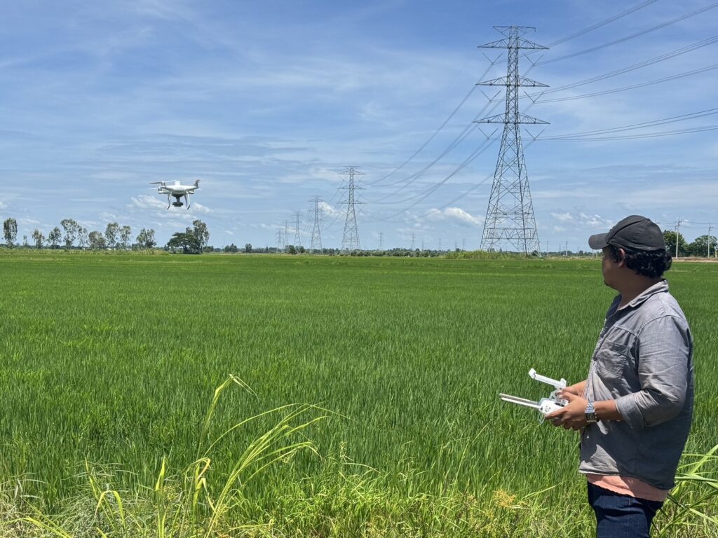
![]() ดร. กฤช เอี่ยมฐานนท์ ผู้อำนวยการศูนย์สารสนเทศการเกษตร มอบหมายให้ส่วนภูมิสารสนเทศการเกษตร ลงพื้นที่สำรวจเพื่อจัดเก็บค่าการเจริญเติบโตของข้าว ร่วมกับการบินถ่ายภาพโดรน เพื่อวิเคราะห์ความสมบูรณ์ของพืชพรรณของแปลงตัวอย่าง เพื่อหาความสัมพันธ์กับข้อมูลดาวเทียมในสองระบบเซนเซอร์ (Sensor) สำหรับการพัฒนาแบบจำลองพยากรณ์ผลผลิต กิจกรรมประยุกต์ใช้เทคโนโลยีภูมิสารสนเทศเพื่อเพิ่มประสิทธิภาพการพยากรณ์ผลผลิตสินค้าเกษตร (ในกิจกรรมย่อย การติดตามเนื้อที่เพาะปลูกและประเมินผลผลิตพืชไร่) ภายใต้โครงการเพิ่มประสิทธิภาพการจัดทำสารสนเทศการเกษตรและการบริหารจัดการข้อมูลขนาดใหญ่ ปีงบประมาณ พ.ศ. 2568
ดร. กฤช เอี่ยมฐานนท์ ผู้อำนวยการศูนย์สารสนเทศการเกษตร มอบหมายให้ส่วนภูมิสารสนเทศการเกษตร ลงพื้นที่สำรวจเพื่อจัดเก็บค่าการเจริญเติบโตของข้าว ร่วมกับการบินถ่ายภาพโดรน เพื่อวิเคราะห์ความสมบูรณ์ของพืชพรรณของแปลงตัวอย่าง เพื่อหาความสัมพันธ์กับข้อมูลดาวเทียมในสองระบบเซนเซอร์ (Sensor) สำหรับการพัฒนาแบบจำลองพยากรณ์ผลผลิต กิจกรรมประยุกต์ใช้เทคโนโลยีภูมิสารสนเทศเพื่อเพิ่มประสิทธิภาพการพยากรณ์ผลผลิตสินค้าเกษตร (ในกิจกรรมย่อย การติดตามเนื้อที่เพาะปลูกและประเมินผลผลิตพืชไร่) ภายใต้โครงการเพิ่มประสิทธิภาพการจัดทำสารสนเทศการเกษตรและการบริหารจัดการข้อมูลขนาดใหญ่ ปีงบประมาณ พ.ศ. 2568 ![]()
![]()
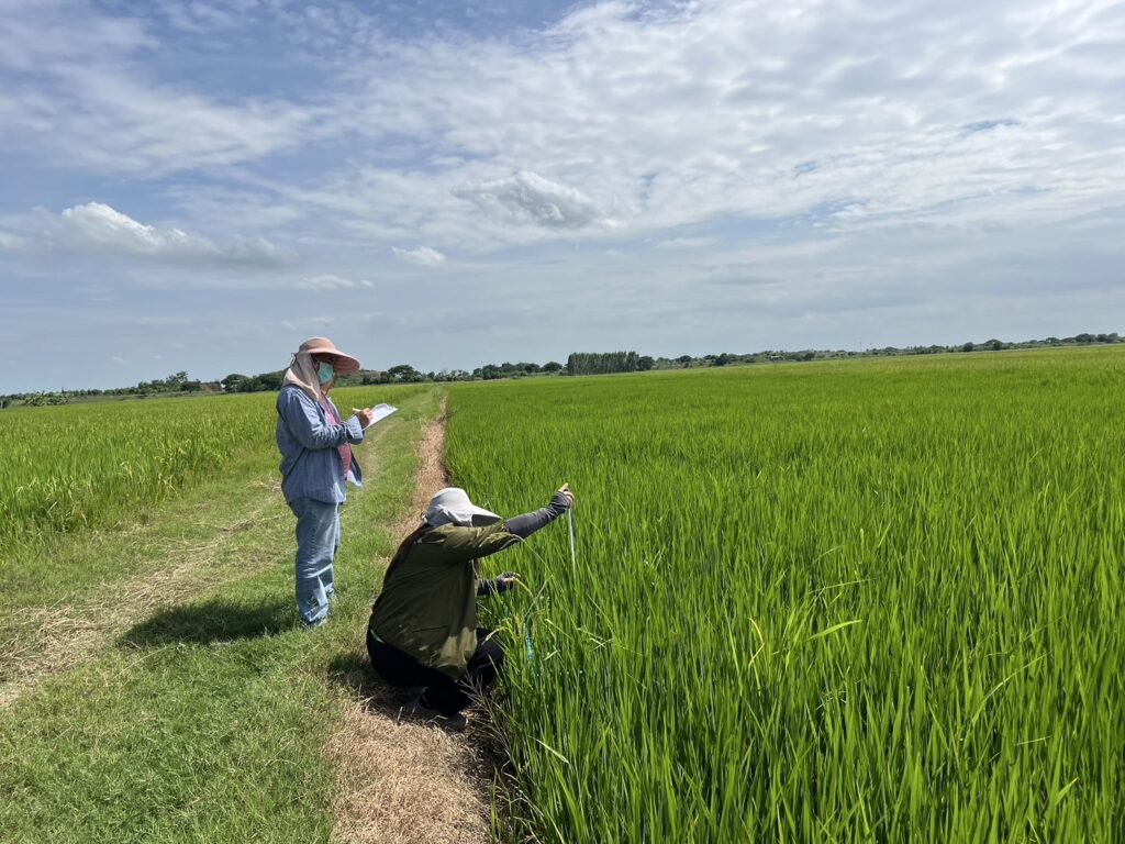
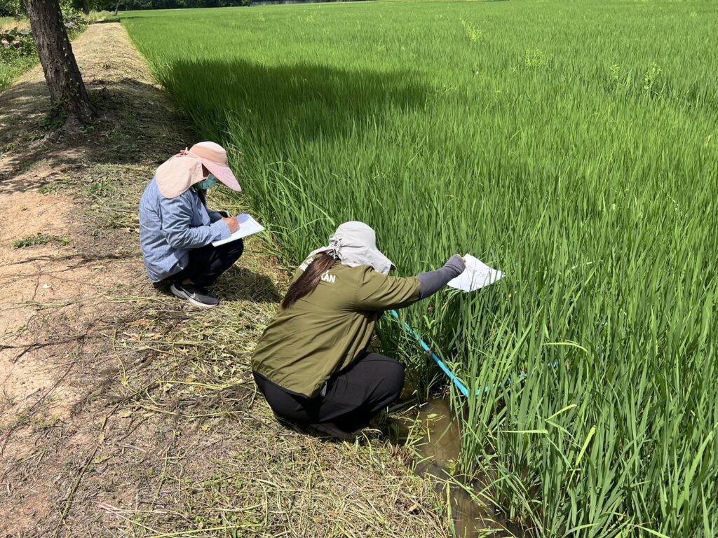
![]() กำหนดดำเนินงานในสินค้าข้าวนาปี ปี 2568 ในพื้นที่จังหวัดสุพรรณบุรี และสิงห์บุรี จำนวน 42 แปลงตัวอย่าง ในการสำรวจครั้งนี้ ดำเนินงานจัดเก็บข้อมูลการเจริญเติบโตของข้าวด้วยวิธีการ/เครื่องมือต่าง ๆ ในช่วงแตกกอ (Tillering) และช่วงตั้งท้อง (Panicle)
กำหนดดำเนินงานในสินค้าข้าวนาปี ปี 2568 ในพื้นที่จังหวัดสุพรรณบุรี และสิงห์บุรี จำนวน 42 แปลงตัวอย่าง ในการสำรวจครั้งนี้ ดำเนินงานจัดเก็บข้อมูลการเจริญเติบโตของข้าวด้วยวิธีการ/เครื่องมือต่าง ๆ ในช่วงแตกกอ (Tillering) และช่วงตั้งท้อง (Panicle) ![]()
![]() ระหว่างวันที่ 23 มิถุนายน – 8 กรกฎาคม 2568
ระหว่างวันที่ 23 มิถุนายน – 8 กรกฎาคม 2568
![]()
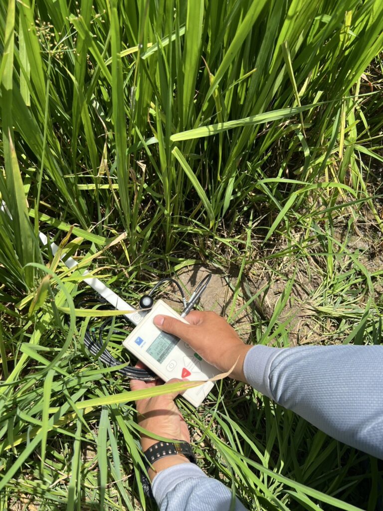
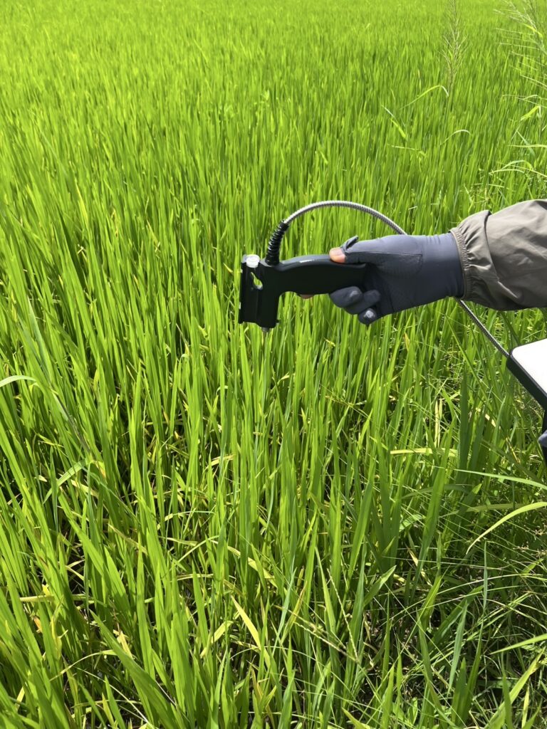
![]() ในการดำเนินงานสำรวจในครั้งนี้ มีการจัดเก็บค่าข้อมูลการเจริญเติบโตของข้าว ที่คาดว่าจะมีความสำคัญในเชิงการพัฒนาของต้นข้าวและผลผลิตข้าว ในช่วงแตกกอ และตั้งท้อง เช่น ค่าความหนาแน่นของต้นข้าว ความลึกของน้ำ ความสูงของต้นข้าว ค่าชีวมวล ค่าพื้นที่ผิวใบ ค่าปริมาณคลอโรฟิลด์ ค่าการสะท้อนแสงด้วยเครื่อง Spectroradiometer สำหรับงานสำรวจระยะไกล (Remote Sensing) (เพื่อเปรียบเทียบกับการสะท้อนแสงในช่วง Blue-Green-Red-Near Infrared กับย่านความยาวคลื่นต่าง ๆ ของภาพถ่ายดาวเทียม) และค่าผลผลิตต่อไร่ จากนั้น ข้อมูลการเจริญเติบโตของข้าวทั้งหมดจะถูกนำมาวิเคราะห์ร่วมกับภาพถ่ายดาวเทียมกำหนดใช้เซนเซอร์ที่แตกต่างกัน คือ ภาพถ่ายดาวเทียมในระบบ Optical Sensor ได้แก่ ภาพถ่ายดาวเทียม Sentinel-2 และภาพถ่ายในระบบเรดาห์ช่องเปิดสังเคราะห์ (Synthetic Aperture Radar: SAR) ได้แก่ ภาพถ่ายดาวเทียม Sentinel-1 ในสำนักงานฯ ต่อไป
ในการดำเนินงานสำรวจในครั้งนี้ มีการจัดเก็บค่าข้อมูลการเจริญเติบโตของข้าว ที่คาดว่าจะมีความสำคัญในเชิงการพัฒนาของต้นข้าวและผลผลิตข้าว ในช่วงแตกกอ และตั้งท้อง เช่น ค่าความหนาแน่นของต้นข้าว ความลึกของน้ำ ความสูงของต้นข้าว ค่าชีวมวล ค่าพื้นที่ผิวใบ ค่าปริมาณคลอโรฟิลด์ ค่าการสะท้อนแสงด้วยเครื่อง Spectroradiometer สำหรับงานสำรวจระยะไกล (Remote Sensing) (เพื่อเปรียบเทียบกับการสะท้อนแสงในช่วง Blue-Green-Red-Near Infrared กับย่านความยาวคลื่นต่าง ๆ ของภาพถ่ายดาวเทียม) และค่าผลผลิตต่อไร่ จากนั้น ข้อมูลการเจริญเติบโตของข้าวทั้งหมดจะถูกนำมาวิเคราะห์ร่วมกับภาพถ่ายดาวเทียมกำหนดใช้เซนเซอร์ที่แตกต่างกัน คือ ภาพถ่ายดาวเทียมในระบบ Optical Sensor ได้แก่ ภาพถ่ายดาวเทียม Sentinel-2 และภาพถ่ายในระบบเรดาห์ช่องเปิดสังเคราะห์ (Synthetic Aperture Radar: SAR) ได้แก่ ภาพถ่ายดาวเทียม Sentinel-1 ในสำนักงานฯ ต่อไป
![]()
![]()
![]() During 23rd June – 8th July 2025, Director of Center for Agricultural Information (CAI) has an assignment to the staffs of Agricultural Geo-Information (GI) Division for field survey in Suphan Buri and Sing Buri provinces. In 2025, the CAI extending these two provinces for representative of rice yield estimation projects. The main objective of this field survey is collecting the essential of rice biophysical variables to develop rice yield model based on linear regression model, which is a sub-activity under “Applying the Geo-Informatics for agricultural yield forecasts and spatial data management”. This activity is one main sub-activity under the “Improving the efficiency of agricultural information management and big data management” project in 2025. The commodity is defined in the wet season rice in 2025
During 23rd June – 8th July 2025, Director of Center for Agricultural Information (CAI) has an assignment to the staffs of Agricultural Geo-Information (GI) Division for field survey in Suphan Buri and Sing Buri provinces. In 2025, the CAI extending these two provinces for representative of rice yield estimation projects. The main objective of this field survey is collecting the essential of rice biophysical variables to develop rice yield model based on linear regression model, which is a sub-activity under “Applying the Geo-Informatics for agricultural yield forecasts and spatial data management”. This activity is one main sub-activity under the “Improving the efficiency of agricultural information management and big data management” project in 2025. The commodity is defined in the wet season rice in 2025![]()
![]()
![]() in the two above provinces and the amount is 42 sample units.
in the two above provinces and the amount is 42 sample units.
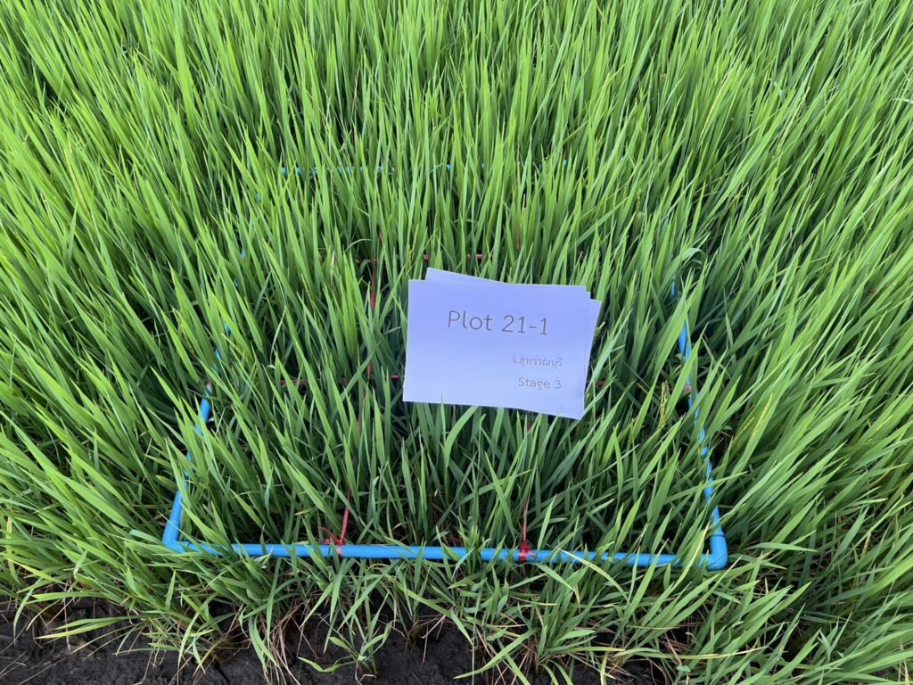
This field survey is collecting several of rice biophysical variables in the tillering stages in the which are relevant to the satellite images. For example, rice density, water depth, rice height, biomass, leaf area index (LAI), chlorophyll contents, reflectance with spectroradiometer for remote sensing (relevant with Blue-Green-Red-Near Infrared corresponded with optical wavelengths and beyond to microwave wavelength), and yield are collected. Finally, these rice biophysical variables analyze their relationships in terms of Pearson correlation and develop linear regression model according to satellite imageries in both optical (Sentinel-2) and Synthetic Aperture Radar (SAR: Sentinel-1) sensor.